Official Name:
Ї”ќчіеЇЊ«µHeXiCunHaoQianOur Name:
ЇЊєµ / HaoGou
Other Name:
/
Period:√ч
/ Ming Dynasty 1368~1644
Location: Є Ћа °,љр≤э –,”ј≤эѕЎ,∆рµг£ЇЇ”ќч±§’тћъ≥Іќч≤а800√„÷єµг£ЇЇ”ќч±§’тћъ≥Іќч≤аЇм…љ…љ—ьі¶ / GanSuSheng,JinChangShi,YongChangXian,QiDianHeXiBaoZhenTieChangXiCe800MiZhiDianHeXiBaoZhenTieChangXiCeHongShanShanYaoChu
°°[
Looking Local List]
Details:≥§≥«ја±р£ЇљзЇЊЇЊ«µ
∆рµгЊ≠ќ≥Єяґ»£ЇґЂЊ≠£Ї°г °д ±±ќ≥£Ї°г °д Ї£∞ќ£Ї
÷’µгЊ≠ќ≥Єяґ»£ЇґЂЊ≠£Ї°г °д ±±ќ≥£Ї°г °д Ї£∞ќ£Ї
«љће„яѕт£Ї
«љћеја±р£ЇЇЊ«µ
љбєєћЎµгЉ∞єє÷юЈљ љ£ЇЇЊ«µљф…љѕ’«љЋж…љЊЌ ∆ѕт…ѕтк——≈ …э£ђ∆р÷єµгµЏ0350-0354µг°£»Ђ≥§223√„°
і”∆рµг÷Ѕ23√„і¶≥цѕ÷µЏ1’џµг£®µЏ0351µг£©°£
і”µЏ1’џµг£®µЏ0351µг£©ѕт…ѕ—”…м÷Ѕ25√„і¶£ђЇЊ«µ≥цѕ÷µЏ2’џµг£®µЏ0352µг£©£ђ”…іЋѕтќчƒѕ„™ѕт160°г°£
і”µЏ2’џµг£®µЏ0352µг£©ѕт…ѕ—”…м÷Ѕ60√„і¶£ђЇЊ«µ”÷≥цѕ÷µЏ3’џµг£®µЏ0353µг£©£ђ”…іЋµгѕтќчƒѕ≥…60°г„™Ќд£ђЇЊ«µ∆¬ґ»‘Љ65°г°£
і”µЏ3’џµг£®µЏ0353µг£©ѕт…ѕ—”…м÷Ѕ115√„ «÷єµг°£
”л÷№±я≥§≥««љће°ҐЈйїрћ®°ҐєЎ±§µ»µƒќї÷√єЎѕµ£ЇґЂƒѕљ”Ї”ќчіе≥§≥«÷єµг£ђќч±±”лЇ”ќч±§-љрі®ѕњ…љѕ’∆рµгѕаљ”°£ƒѕ≤аљф“јЇ”ќчіе…љѕ’«љ“ј…љ ∆ѕт…ѕ≈ …э°£
ѕ÷„і£Ї
Type:
Protection Level:°°
Content:
Memo:
Other Records:
Distribution:
visit location in Tianditu Map[recommend] Distribution:
visit location in Tencent QQ Map Distribution:
visit location in Google MapDistribution:
visit location in Baidu MapNational ID:620321382202170001
Action:[
 Save in Data Basket
 ]
Picture:
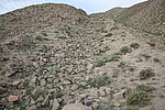
Click the thumbnail to view the Big Pic. Click the Big Pic to Hide the Big Pic![Caption:Ї”ќчіеЇЊ«µ
loading images --Please wait...]()
![Caption:Ї”ќчіеЇЊ«µ
loading images --Please wait...]() Photo Links
Photo Links:
°° Search ::
  Favorite/My Favorite :: Recent Changes :: :: Login